Sea Level Rise Flood Connectivity Between Bay Area Jurisdictions
Sea Level Rise (SLR) Flood Connectivity between Bay Area Jurisdictions is one of several products being produced as part of CHARG’s Technical Priorities Plan. To download maps for the entire Bay and by county, go to the links at the bottom of this page.
Purpose of the Connectivity Assessment
Around the San Francisco Bay shoreline, flooding is often managed at the local level (i.e., by an individual city or county) with infrastructure solutions like levees and floodwalls. While this individual-level solution may work in limited areas, those same solutions may prove ineffective when flood water inundates low-lying areas of one city and flows across jurisdictional boundaries to another city. Sea level rise (SLR) will only exacerbate these flood hazards and the degree to which neighboring jurisdictions are hydraulically connected. CHARG undertook this assessment to identify this hydraulic connectivity between San Francisco Bay shoreline jurisdictions. Cities, counties and regional agencies are encouraged to refer to the maps to help identify the full range of stakeholders who should be engaged in SLR adaptation efforts.
Interpreting the Connectivity Assessment Maps*
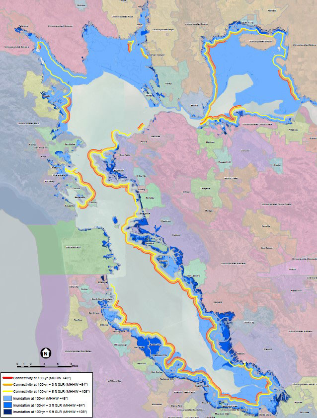
The assessment of SLR Flood Connectivity between Bay Area Jurisdictions uses shoreline topography and San Francisco Bay flood water levels to map low-lying pathways where flood waters cross jurisdictional borders. The results demonstrate the interconnectedness of flood management challenges along the Bay shoreline and escalating need for multi-jurisdictional coordination as sea levels rise.
The maps were constructed using a 100-year flood event and three sea level scenarios:
• Present-day sea level
• 3 feet SLR
• 5 feet SLR
Inundation extents are based on mapping conducted for the Bay Conservation and Development Commission’s Adapting to Rising Tides project (BCDC, 2017). Different color lines show connectivity for each flood scenario, with the red line signifying immediate need for coordination between jurisdictions due to present 100-yr flood hazards, and orange and yellow lines suggesting coordination needed in current planning activities to prepare for future conditions.
* Flood connectivity is based on readily available information, and only intended for high-level regional planning. Actual flood management decision-making authority remains with local agencies and landowners.
Click on the links below to download maps:
All our creeks drain to San Francisco Bay.
As sea levels rise, high water along the shore will flood our creeks and communities more often.
Marin County

Palo Alto Airport
Milpitas